News from Sierra Nevada Guides

Latest news from the Sierra Nevada Mountains of Southern Spain

Thursday, 20 March 2014

Guided Walks in the Alpujarra and Sierra Nevada

Sierra Nevada Guides are pleased to announce their programmes of guided walks for the coming spring and summer seasons. Details are on the Sierra Nevada Guides website.

Walking in The Taha Gorge


The Spring programme of walks in the Alpujarra also includes an ascent of Trevenque 2079m which though not being in the Alpujarra is a fine "low altitude" peak sometimes described as the "Matterhorn" of the Sierra Nevada. The walk through the Taha being one of the best hill walking days you'll find anywhere...........

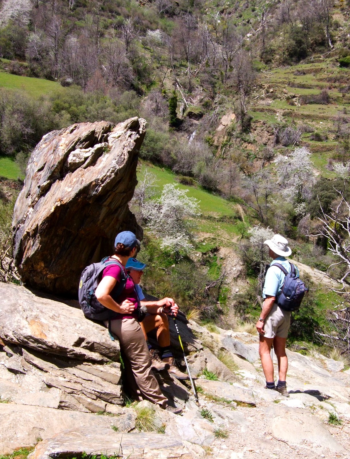
Walkers in the Alpujarra
Mondays - Hills and Terraces and Acequia's above Lanjaron, walking with a local landowner / guide who will explain the local landscape, farming and wildlife. 5 to 6 hours, a little strenuous.

Tuesdays - A circuit in the Taha walking a medieval path through old "arab" villages through terraces and a spectacular gorge crossing a Roman bridge. Not to mention the water fountain with naturally carbonated water! 5 to 6 hours walking, strenuous.

Wednesdays - An ascent of Trevenque 2079m, the Matterhorn of the Sierra Nevada. 5 hours walking, with one steep strenuous ascent / descent.

Thursdays - A circuit in the Rio Poqueira and the pretty white villages of Capileira, Pampaneira and Bubion.
5 to 6 hours of walking a little strenuous.


Fridays - Glimpses of Mulhacen!
A walk in the forrests above Capileira to Hoya del Portillo and Puerto Molina 2380m. 5 to 6 hours walking a little strenuous.

All of the guided walks are priced at 40 Euro's per person and are led by qualified British, International Mountain Leaders.


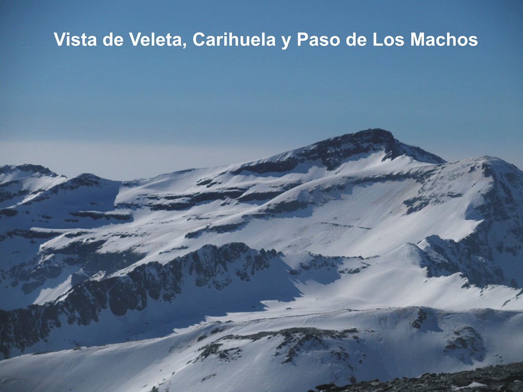
The Summer programme - of walks in the Sierra Nevada is aimed at tackling the higher peaks which will be a cool relief to the heat of summer.  These include ascents of Mulhacen 3482m the highest mountain in mainland Spain, Veleta 3396m,  Alcazaba 3364m and Caballo 3011, Europes most westerly 3000m peak.


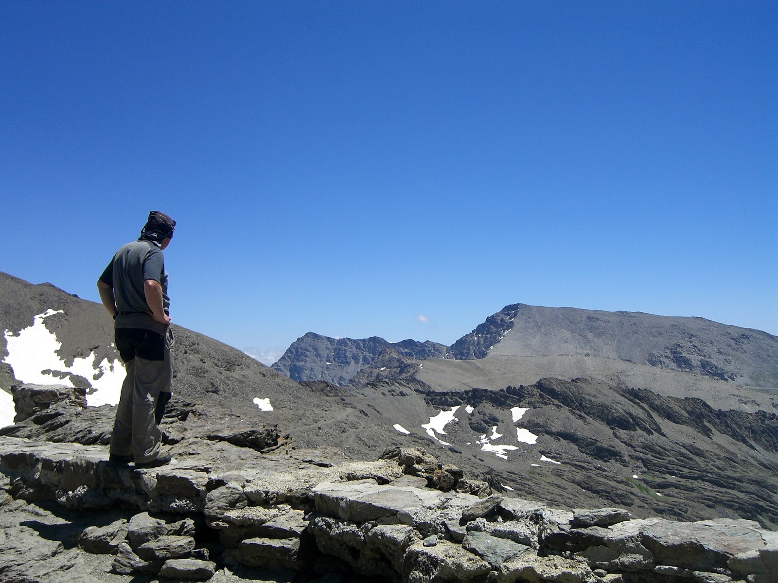
Walkers at The Caldera Refuge, Sierra Nevada

The upper Rio Lanjaron near Caballo
Mondays - Mulhacen 3482m, the highest mountain in mainland Spain. Starting in Capileira and catching the National Park bus to 2700m, we ascend Mulhacen's south ridge to the summit. Our descent is down the west flank with glimpses of the impressive north faces of both Mulhacen and Alcazaba before reaching the Caldera Refuge, Rio Mulhacen and Poqueira Refuge. 8 hours of walking, 1100m of ascent, fairly strenuous.

Tuesdays - Veleta 3396m, the 2nd highest mountain in the Sierra Nevada. Starting from Hoya de la Mora at 2500m.  After the summit we visit the Carihuela Refuge and the Lagunas de la Virgin. 7 hours. A day mainly on good paths that is not too strenuous.

Wednesday - Alcazaba 3364m, the 3rd highest mountain in the Sierra Nevada and most remote of the big three. Starting in Capileira and catching the National Park bus to 2700m, we ascend Mulhacen's south ridge before traversing around to Siete Lagunas. We then make a circuit on Alcazaba descending through Siete Lagunas with its wonderful flowers before traversing back around Mulhacen to the start.  7 to 8 hours of walking with 900m of ascent, some steep and off path.  This is a strenuous day.

Thursdays - Caballo 3011m, Europe's most westerly 3000m peak. Not to be missed or underestimated. A route taking in not only the summit of this fine peak but our descent takes us to the Caballo Refuge and into the upper Rio Lanjaron. 8 hours of walking, 1100m of ascent, a strenuous day out.

Fridays - Mulhacen 3482m, a repeat on Monday's itinerary.

Like the Spring itinerary, all of the guided walks are priced at 40 Euro's per person and are led by qualified British, International Mountain Leaders.

Further details and how to book these walks are on the Sierra Nevada Guides website:
Spring Programme of walks in the Alpujarra

Summer programme of walks in the Sierra Nevada


Sierra Nevada Mountain Rescue

Helicopter landing at the Refugio Poqueira in winter
Spain does not have a volunteer mountain rescue service, however a dramatic rescue of 2 climbers from the north face of Mulhacen on Monday 17th March demonstrates that if you do get into difficulties in the mountains, rescue is possible.

The 2 climbers had left the Refugio Poqueira to climb the rugged north face of mainland Spain's highest mountain where winter conditions include snow, ice and often high winds.  When they had not returned by late evening, the guardian at the refuge informed the Guardia Civil, who had managed to contact the climbers on their mobile phone to ensure they were safe, but belayed on the mountain face. The following morning a rescue helicopter managed to find them and help them down.

Although a difficult situation to be in, it is very comforting to know that our friends at the Refugio Poqueira are vigilant when asking where we are going and the Guardia Civil have skilled mountaineers able to undertake a rescue should this be needed.

Sierra Nevada Mountains in Winter (taken by Refugio Poqueira)


You can read more about the rescue in El Mundo, including a great video clip of the rescue.

The Refugio Poqueira publishes regular updates on conditions in the mountains during the winter months.

Tuesday, 7 January 2014

Snowshoeing in Spain’s Sierra Nevada Mountains


Snowshoeing in Spain’s Sierra Nevada Mountains

Although this is Southern Spain, close to the Mediterranean and Africa, The Sierra Nevada boasts Europe’s most southerly ski resort and mainland Spain’s highest mountain, Mulhacen 3482m above sea level. As an indication, the ski season usually starts here at the end of November and finishes in May with a celebration of skiing in the morning and swimming in the sea in the afternoon! However there are sometimes during the season when the snow starts to get a bit thin though we can usually find somewhere to snowshoe.

Sally learning to move on snowshoes

The joy of exploring the Sierra Nevada on snowshoes is that the area is mainly undeveloped, so unlike alpine ski resorts you can get a real feel of wilderness away from crowds, ski lifts and prepared snow slopes. Our snowshoeing days start from one of the pretty high villages (usually with coffee) before heading up dirt track roads as high as possible into the snow. Occasionally we have to walk a bit before putting on snowshoes but often we can snowshoe from the car.


The way to Pico de los Machos 3088m
Our routes usually start up through the forests before gaining the open slopes above the tree line. On the majority of days we enjoy blue skies and sunshine which is a distinct advantage over the traditional alpine resorts, though if the weather is poor we can always walk the spectacular paths in the Alpujarra (the lower southern slopes of the Sierra Nevada).


On our snowshoeing holidays we like to spend a night up at the Poqueira Refuge (2500m) which although bunk accommodation has a good dining room, bar and made all the better by the log fire.

The Poqueira Refuge, superb snow and blue skies!

Snowshoeing is a little more strenuous than normal walking, but we are often walking over terrain where it would be impossible to walk without either snow shoes or touring skis. That said the normal snowshoeing day is around 10am until 4pm though shorter if conditions dictate.


In short, snowshoeing is good fun; sociable and takes you to places not normally visited in the winter months. Sierra Nevada Guides are all International Mountain Leaders, the qualification recognized in Spain (and internationally) for being a snowshoeing Guide.


Sierra Nevada Guides are offering guided snowshoe hikes from 50 Euro’s per person including the hire of snowshoes.


Monday, 18 November 2013

Sierra de Lujar.

Whilst reaching a height of 1,850m the Sierra de Lujar range to the south of the Sierra Nevada is generally overlooked by walkers visiting the area. Perhaps the reason is that with its whale bacl appearance and lack of rocky peaks it just does not appeal. There are routes here however with one of the better ascents forming a hard day out with about 1,200m of ascent. The route starts in the Baranco de Castilejo a steep sided valley due south of Orgiva. The baranco , which holds some single pitch climbs on outcrops , provides an easy route in as there is a mine access track running up it from the main road. The track splits at about 700m with the main branch doubling back to climb the western side of the valley to the mine workings above. Our route climbs the eastern side on a less well used track before reaching a fire break/track which runs south along the crest of a narrow ridge that climbs steeply upward. The track provides a clear route until about 1.000m where it reverts to a path running up the middle of the fire break which still follows the crest. The route now steepens and at 1250m begins to develop a more rocky nature with a number of limestone outcrops along the crest. The first three are by passed to the right (west) though provide short scrambles. After a further 300m of ascent the ridge fades into the main bulk of the mountain. From here you will see the masts at the summit, head due south to and these. Just before the first of the masts you will reach a narrow tarmac road, follow this past the first of the masts to bear right just before the second group to follow a stone path bearing right before the third group of masts. The path now narrows and heads west to cross the head of the Baranco de Castilejo and reaches a minor peak. Now narrower the path crosses open plateau to reach the edge of a one forest. From here head right (north) through the forest. As you emerge cross a distinctive limestone ridge to enter a second narrower band of older pine trees. Leave the second band of trees and head to a clear track still heading north across the hillside. As the track turns west continue north across virgin hillside to reach the head of a broad firebreak which creates the start of the descent route. Cross a number of narrow tracks until at about 1,250m you reach a well used track. There are some large caves off to the left (west).This now heads east to pass the ruins of some mine buildings before zigzagging down the mountainside back to the start of the route.

Tuesday, 12 November 2013

Winter Skills Course – Sierra Nevada, Spain including a winter ascent of Mulhacen.


Winter Skills Course – Sierra Nevada, Spain.

Learn the skills to walk confidently in the mountains in winter. 
A week of winter mountaineering skills training, in Spain’s beautiful Sierra Nevada mountains. Including a winter ascent of Mulhacen 3482m mainland Spain’s highest mountain.

1st February to 8th February, 2014.

The course is being run / directed by Andy Say (MIC, IML) of Mountain Training England and supported by IML’s from Sierra Nevada Guides (Jane Livingstone, Martin Riley and Michael Hunt).


The course will be hotel based in Lanjaron with 2 nights spent in the mountains, Poqueira Refuge and snow shelter. Cost, excluding flights, £795. This includes meeting you at Malaga Airport, full board accommodation and returning you to Malaga at the end of the week.

Course Outline:
Sat 1st Feb.              Arrive. 
Introductions, course outline and equipment brief.

Sun 2nd Feb.            Moving on snow and ice.
An introduction to ice axe and crampon use.  Simple secure movement; step cutting, self-belay, self-arrest.  Movement on snow with crampons and snowshoes.


Mon 3rd Feb.           Safer travel in the winter environment.
Snowpack formation and analysis in the field.  Route planning from weather/snowfall history. Simple observation and tell-tale signs.  Test pits.  Following a safer route.
Tue 4th Feb.            Looking after others. 
The use of the rope in a winter environment.  
Snow and ice belays.  Retreat using the rope.

Wed 5th Feb.            Journey up the hill.
Putting it all in to practice.  Night in Poquera Refuge.

Thur 6th Feb.            Emergency procedures.
Snow shelters, bivouac skills.  Night out on the hill, either Caldera Bivi Refuge or in snow shelters.

Fri 7th Feb.              Ascent of Mulcahen 3482m (highest mountain in mainland Spain) and descent to valley.

Sat 8th Feb.              End of course and depart.

Further details can be obtained from either Mike or Jane at Sierra Nevada Guides.              Email: info@sierranevadaguides.co.uk

                        Tel:            01433  639  368

Monday, 15 July 2013

Magnificent Mulhacen!


Magnificent Mulhacen!

It’s normal for us at Sierra Nevada Guides to be guiding people up Mulhacen which at 3482m is the highest mountain in The Sierra Nevada and the whole of mainland Spain. However yesterday, having a day off we decided to climb Mulhacen ourselves for the sheer enjoyment of it. Legend has it that Mully Hasan the deposed and penultimate Arab King of Al Andalus is buried on the mountain.


Mulhacen's West Ridge from The Caldera Refuge

Most people tackling Mulhacen take the National Park bus from Capileira up to Alto del Chorrillo at 2700m and ascend and descend Mulhacen’s South Ridge. It’s fine to use the bus and the South Ridge as part of the excursion but to only do a “there and back from the bus” is a short day and will leave you thinking it’s not been a proper day out!


Setting out early in summer is the best tactic. This allows you to get the climbing done before the heat of the day starts to sap your energy. We started from Hoya del Portillo 2160m at 7.30am. It was cold, 10 degrees C and for the first 20 minutes we were in the forest so no sun. Still the motto is: start cold and warm up walking up hill! By the time we had reached the view point of Puerto Molino 2380m (30 minutes) we were warm! Our route continued along the ridge of Prado Llano 2577m to 2622m before joining the old road along to Alto del Chorrillo arriving there for a breakfast break at 9.15am.


The local sandwort growing near Mulhacen's summit
The actual ascent of Mulhacen along the south ridge is pleasant, and in summer a well defined path with cairns marking the way through the screes just below the subsidiary summit of Mulhacen II at 3361m. Even though we stopped to take photo’s of plants and beetles, we reached the summit at 11.20am a total time of 3 hours and 50 minutes. A distance of 11.4Km with a total height gained of 1412m. An hour and 20 minutes ahead of Naismith (The rule for calculating the time to walk up mountains – allow 4Km per hour and add a minute for every 10m of ascent).


Iberian Ibex near Mulhacen's Summit


We were ahead of the crowd from the bus so the summit was fairly quiet. There was a small group of “Cabra” the Iberian Ibex mooching around not particularly afraid of us, the usual Alpine Accentor and a large squadron of Swifts giving a good display of aerobatics.


After a short break on the summit, it was time to head downwards before the crowds from the bus arrived. There is a zig zag path down the screes of Mulhacen’s West flank which we took heading to the Collado de la Mosca which gives great views of both Mulhacen’s and Alcazaba’s 3371m North Faces. A further 10 minutes and you are down to the Caldera Hut, an unmanned “bivouac” hut with bunks, tables and chairs. From here there is an impressive view back up to Mulhacen’s summit. A spot of lunch was called for at The Caldera!

Mulhacen's Summit - 3482m

With clients if we had caught the bus we would continue down to the Poqueira Refuge 2500m to make a circuit back to Hoya del Portillo. However as we had not walked the old road back to Alto del Chorrillo for a few years we though we’d re-acquaint ourselves with this option. It proved as boring as we remembered it though a useful way out if the weather turns nasty. From Alto del Chorrillo we then returned the way we had ascended finally arriving back to Hoya del Portillo at 3.30pm.

All that remained was to drive back to a bar in Capileira for the customary drink and plan for the next outing!


We are always happy to respond to emails answering questions about the area.

Saturday, 13 July 2013

Summer in The Sierra Nevada – It’s cool at altitude!


Summer in The Sierra Nevada – It’s cool at altitude!

Although summer has been a few weeks late in arriving this year, it has now arrived and is firmly established. Temperatures in the villages have been around 34 degrees C in the afternoons and barely dropping below 20 degrees at night. Two days ago I found it hard to sleep as the bedroom was airless and it was too hot to be comfortable so I decided to check out the conditions on Veleta 3394m the second highest in Spain’s Sierra Nevada.
The Sierra Nevada Violet (Viola crassiuscula)

Leaving home at 6am where it was 21 degrees I drove to Hoya de la Mora (2500m) where it was a cool 13 degrees and felt distinctly cooler with a brisk wind blowing. The ascent of Veleta is one of the easiest of all the mountains in the Sierra Nevada. A gentle ridge and fairly good path for all but the final 200m of ascent where there is a steep zig zag path up through scree and boulders. Reaching Posiciones del Veleta at 3100m a Griffon Vulture soared overhead reminding me that I always see them when on Veleta. By the time I got the camera out and switched on it was too far to make a decent picture.  In total it took me two hours to reach the summit and although there was snow around, I didn’t have to cross any patches on my ascent. For most of the climb I was just about warm enough in shorts and a t shirt though my hands started to get cold near the summit. Once on the summit and no longer generating heat from the exertion of ascending I needed a windproof fleece hat and gloves. I guess it was around 5 degrees with the windchill. Cool!


“Blue Dreams” (Chaenorrhinum glareosum).

I choose to descend towards the Carrihuela refuge 3205m down by the old track that used to cross the Sierra Nevada from Granada to Capileira on the south side of the range. As usual for this time of year the track was buried in snow for about 1Km beyond the refuge. On the way to the refuge there were a number of alpine plants coming into flower as the snow had recently receded. And I managed to get a few photo’s before the battery in my camera gave up! Notable were the Sierra Nevada Violet (Viola crassiuscula) and “Blue Dreams” (Chaenorrhinum glareosum). It was at this point with the camera out of action that I noticed a group of six Grifon Vultures circling above me!


Griffon Vulture

At the Carrihuela refuge I met a cyclist who had wanted to take the old road and cross the snow with his bike heading for Capileira.  The snow was still frozen hard and the slope to cross is very steep with a bad run off if you were to slip. Fortunately he had already decided against it though it would be a massive 120Km detour. He said he’d cycled the route a few years ago and I left him considering whether or not to wait until late afternoon when the snow might be safe enough for safe passage without crampons.

Mulhacen from the Carrihuela Refuge

The rest of the descent back to Hoya de la Mora was a pleasant stroll though I could feel it warming up! Soon the gloves came off, the fleece hat was replaced by a buff and eventually the windproof came off too. It was a pleasant 22 degrees back at the car and I headed to the “University Albergue” for a cool beer and tappa.
Veleta from Hoya de la Mora
Sierra Nevada Guides are the only qualified British Guides working in Spain's Sierra Nevada Mountains.  We are always happy to answer your questions about the area.