News from Sierra Nevada Guides

Latest news from the Sierra Nevada Mountains of Southern Spain
Showing posts with label Sierra Nevada. Show all posts

Friday, 13 September 2019

Staying Safe in the Mountains


International Mountain Leaders have to complete Professional Development courses each year.
  This year Mike, Jane and Steve from Sierra Nevada Guides were joined by Tom, another IML to spend 2 days in the high mountains looking at techniques for keeping our clients safe on the sometimes steep and rocky terrain we often find in the Sierra Nevada. Part of our reasoning for choosing the Sierra Nevada was not only the benefits learning in the terrain we regularly use, but also southern Spain’s usually warm sunny weather.


We had agreed with BAIML that Steve as a Mountain Instructor and Course Director for Mountain Leadership and Skills in Ireland, could facilitate the course, and this turned out to be a good decision, as he is a really great tutor.

We used the University Albergue at 2500m as our base and met there on the first evening.  Tom had warned us the previous weekend that the weather forecast was not looking good.  We were a little sceptical of his suggestions that we might be faced with snow, as we had been above 3000m earlier that week walking in light clothes quite happily.  However we were prepared with warm clothes as we read about the ‘gota fría’ heading our way.  This is a cold front which sometimes sits over eastern Spain bringing unusually cold temperatures and often torrential rain.  Steve was driving down from near Murcia and found himself in the rain!

After an enjoyable evening catching up, we had an early start the next morning to plan the day.  We had booked places on the micro-bus which is operated by the National Park to take visitors up to 3000m and provides some interesting facts about the environment on the way.  
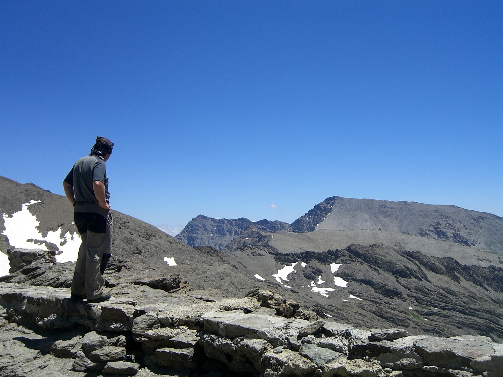
Our original plans had been to follow the easy scramble towards the summit of Veleta, talking about safety and route choice on the way. However the wind and cold meant this would have been unwise and unsafe so instead we took our ropes and warm clothes to the Carrihuela bivouac refuge at 3205m and used this as ‘basecamp’.

During the morning, Steve led us through some revision of knots, safe anchors and spotting.  It was good to remind ourselves of how much we already knew from both our Mountain Leader and International Mountain Leader courses as well as learning some new techniques.  For me one of the highlights was a really simple game for moving over steep ground, which involved holding a flat stone on the back of each hand whilst walking over the rocks at the back of the refuge. This meant you had to stand upright and hold you hands flat for balance (otherwise you will drop the stones) and it really worked!

After a break for lunch, we looked at belay techniques and using a rope to support a client who was lacking confidence in the terrain.  We then wandered around the rocky landscape underneath Veleta using both ropes and slings to support each other before returning to the bus.

It had been an excellent few hours, and we had managed to find shelter from the increasingly strong winds and almost freezing temperatures - southern Spain that day was sunny, but certainly not warm!!

During the early evening Tom and Steve spent an hour or so talking about photography. Tom is a really good photographer and Steve had just bought a new camera.  No CPD points for this session (though I am sure we could have made the justification for them), but some stunning photos of the sun setting over an increasingly stormy summit of Veleta were an added bonus.

The second day dawned but rather than sun, the tops were covered with quite a dusting of snow.  We debated our options and decided we more learning would take place by staying around the hostel as traveling any higher - this turned out to be a good move, as the driver of the bus returned after the early run saying there was too much ice and snow to be safe and he would not have taken us!

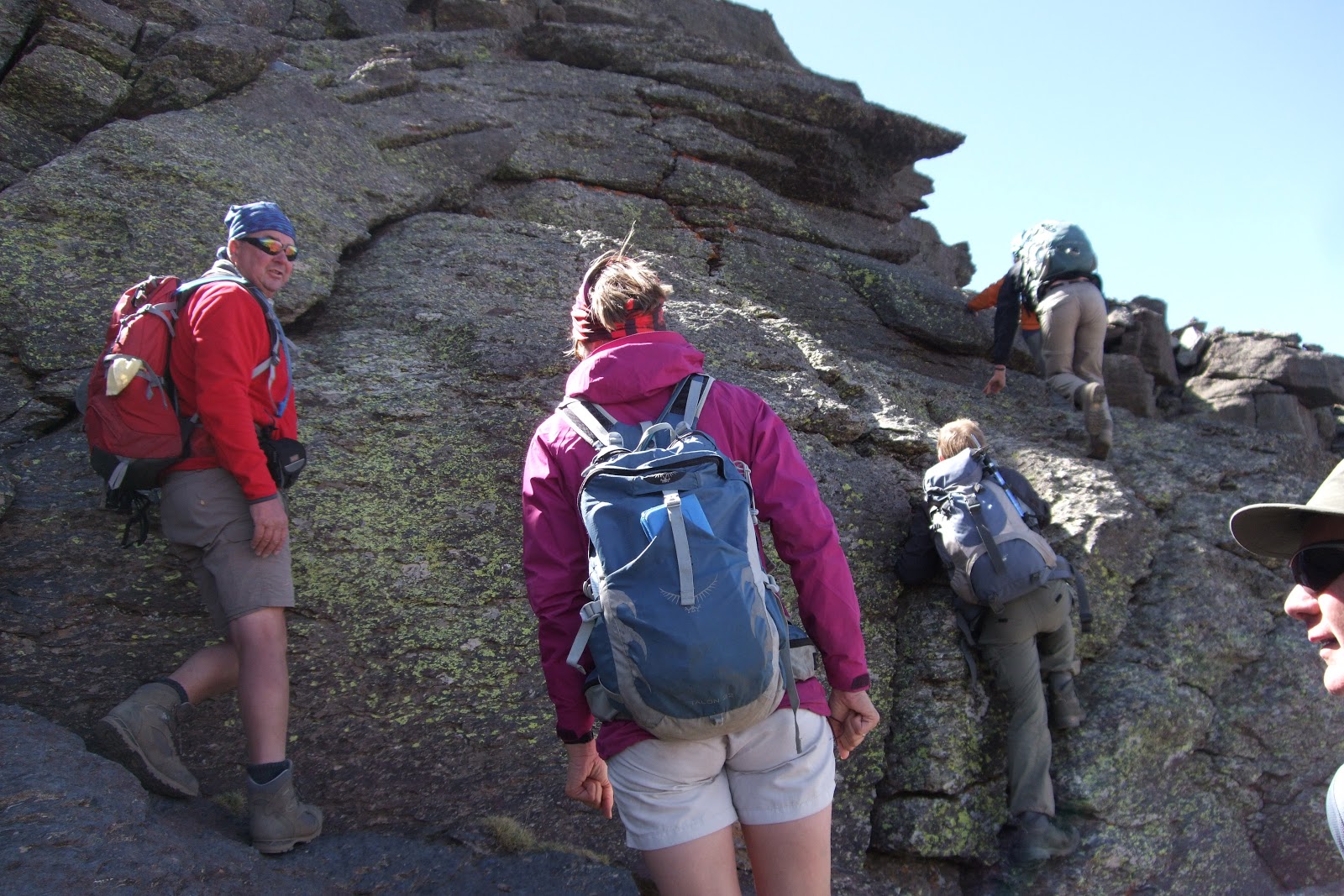
That morning we spend some time revising abseiling techniques (both the traditional and South African) and debating when each might be used.  


After warming coffee and cake in the hostel bar we made use of some nearby fencing (which is made of wooden poles and wire rope) to talk about keeping clients safe on fixed equipment, and when we might take people over what is called ‘the guides path’ - a short section of chain on a path near the old Sierra Nevada road.

The final hour we had some more practice with ropes and slings on the steep rocky paths behind the hostel.  

We retreated to the warmth of the hostel bar for a final review and debrief before sending Steve off to do battle with the weather (the forecast for Murcia and Alicante was severe and we read the next day of some deaths on the roads due to flooding).

A really great 2 days, lots of learning, sharing and reviewing our practice.  We all agreed it would be good to do something similar the following year.

Friday, 28 November 2014

Winter Mountain Skills Course


Winter Mountain Skills Course

Sierra Nevada Guides run a series of winter skills events in Spain’s Sierra Nevada mountains each winter. The aim is to give mountain walkers the breath of skills and experience necessary to tackle “non technical” mountains. i.e. mountains that can be ascended without the need for ropes and climbing ability.

Winter Skills, Learning the Ropes!

Winter Skills, Building Snow Shelters
These courses cover the following topics:
Walking with crampons;
Walking with snowshoes;
How to use an ice axe to cut steps and to arrest you if you fall down a slope;
Navigation and route planning;
Building emergency shelters and snowholes;
The use of a rope in emergency situations;
The use of avalanche tranceivers;           
Mountain weather;            and
Snowpack analysis.

Winter Skills, Ice Axe Arrest
Because for most people, the course is a holiday we consider it important to make it fun and to have some mountain objectives. For the week long course we aim to ascend mainland Spain’s highest mountain, Mulhacen 3482m from the Refugio Poqueira. The week long course spends 3 nights in a hotel and 4 nights at the Refugio.

The course is headed by Andy Say (IML and MIC) the Chief Officer of Mountain Training England and staffed and supported by IML’s from Sierra Nevada Guides.


For 2015 we are running from 31st January to 7th February.  Cost £825, this includes airport pick ups from Malaga Airport, a week of full board accommodation and tuition. All you need to provide are your flights, personal equipment and beer money!


Sierra Nevada Guides will provide any ropes, snowshoes, helmets, tranceivers and snow shovels, though you are welcome to provide your own.


Winter Skills - Relaxation!!
You can read more about walking in the Sierra Nevada mountains in our article winter on UK Hill Walking.


Monday, 25 August 2014

Day walks from Granada

As well as offering a great city break Granada is also ideally based for walking in the Sierra Nevada range. The mountains lie just east of the city and are designated as a Parque Nacional because of their important habitat and landscapes. Walking in the Granada area great at any time of the year and couldn’t be easier to access from the city. Day walks can be arranged to suit a wide range of abilities and interests from rugged 3,000m peaks to low level cool gorge walks. Examples of the walks include Monachil Gorge , a stunning medium grade walk in the magnificent rock gorge of the Rio Monachil. The path clings to the rock face of the gorge, passes through natural rock tunnels and crosses the river on a number of suspension bridges . This is a great adventure for families groups or individuals and can be undertaken at any time of the year. Verada de Estrella. Following the route of an old mine access track we walk into the north side of the Sierra Nevada range. The high mountain scenery of this route is breathtaking with views of the north faces of the three main peaks of the range , Alcazaba , Veleta and Mulhacen. Veleta. High above Granada at 3396m this is the second highest peak in the range yet can be scaled via a non technical walking route from Hoya de Mora just 45 minutes drive from Granada centre. This is a challenging days walking achievable by those with a reasonable level of fitnes. For more information see

Friday, 22 August 2014

The Three Peaks


The Three Peaks

A lot is made in the U.K. of the “3 Peaks” though this means different things to different people.  There is the Yorkshire 3 Peaks challenge whereby you have to complete a round of Ingleborough, Great Whernside and Pen-y-Gent in under 12 hours and the National 3 Peaks Challenge which is an ascent of Snowdon, Scafell Pike and Ben Nevis, usually in under 24 hours.

Mulhacen's West Ridge seen from The Caldera Refuge
However here in the Sierra Nevada we have our own 3 Peaks Challenge, an ascent of Mulhacen 3482m, Veleta 3394 and Alcazaba 3371m. Some seriously high mountains compared to their U.K. counterparts.

Summit of Mulhacen 3482m
Mulhacen3482m the highest mountain in mainland Spain is named after Mully Hassan the penultimate Arab ruler of this part of Spain.

Veleta 3394m is the 2nd highest mountain in the Sierra Nevada and 3rd highest in  mainland Spain (after Aneto 3404m in the Pyrenees). Veleta translates from the old Arabic as The Weather Vane and is clearly seen from The Alhambra Palace in Granada where the Arab Kings resided.

Alcazaba 3371m is the 3rd highest in the Sierra and joint 4th / 5th in height in mainland Spain (Equal with Pico Posets also 3371m). Alcazaba translates as The fortress, aptly named as its most commonly viewed from the North revealing its awesome North Face.

Although it is possible to complete all 3 peaks in a day as a challenge, this would really spoil the enjoyment of a truly great mountain walking experience. We would highly recommend allowing for 3 days in the mountains spending 2 nights at the Refugio Poqueira as the best option for 
completing the Sierra Nevada 3 Peaks.

Near the Summit of Veleta 3394m
Day 1, Alcazaba and to the Refugio Poqueira.

Day 2 Veleta from the Refugio Poqueira.

Day 3 A circuit on Mulhacen returning to the valley.

Sierra Nevada Guides would be happy to facilitate your 3 peaks expedition or include it as part of a weeks walking taking in some of the other great mountains the Sierra Nevada has to offer.


Sierra Nevada Guides are the only qualified British Guides (International Mountain Leaders) living and working in the Sierra Nevada. Details about the guides and their qualifications are listed on the Sierra Nevada Guides website.

Alcazaba 3371m - A very impressive mountain!
If you are planning a visit to the Sierra Nevada, there is much useful information on the Sierra Nevada Guides website and we are always happy to advise on routes and conditions.


Monday, 18 November 2013

Sierra de Lujar.

Whilst reaching a height of 1,850m the Sierra de Lujar range to the south of the Sierra Nevada is generally overlooked by walkers visiting the area. Perhaps the reason is that with its whale bacl appearance and lack of rocky peaks it just does not appeal. There are routes here however with one of the better ascents forming a hard day out with about 1,200m of ascent. The route starts in the Baranco de Castilejo a steep sided valley due south of Orgiva. The baranco , which holds some single pitch climbs on outcrops , provides an easy route in as there is a mine access track running up it from the main road. The track splits at about 700m with the main branch doubling back to climb the western side of the valley to the mine workings above. Our route climbs the eastern side on a less well used track before reaching a fire break/track which runs south along the crest of a narrow ridge that climbs steeply upward. The track provides a clear route until about 1.000m where it reverts to a path running up the middle of the fire break which still follows the crest. The route now steepens and at 1250m begins to develop a more rocky nature with a number of limestone outcrops along the crest. The first three are by passed to the right (west) though provide short scrambles. After a further 300m of ascent the ridge fades into the main bulk of the mountain. From here you will see the masts at the summit, head due south to and these. Just before the first of the masts you will reach a narrow tarmac road, follow this past the first of the masts to bear right just before the second group to follow a stone path bearing right before the third group of masts. The path now narrows and heads west to cross the head of the Baranco de Castilejo and reaches a minor peak. Now narrower the path crosses open plateau to reach the edge of a one forest. From here head right (north) through the forest. As you emerge cross a distinctive limestone ridge to enter a second narrower band of older pine trees. Leave the second band of trees and head to a clear track still heading north across the hillside. As the track turns west continue north across virgin hillside to reach the head of a broad firebreak which creates the start of the descent route. Cross a number of narrow tracks until at about 1,250m you reach a well used track. There are some large caves off to the left (west).This now heads east to pass the ruins of some mine buildings before zigzagging down the mountainside back to the start of the route.

Tuesday, 12 November 2013

Winter Skills Course – Sierra Nevada, Spain including a winter ascent of Mulhacen.


Winter Skills Course – Sierra Nevada, Spain.

Learn the skills to walk confidently in the mountains in winter. 
A week of winter mountaineering skills training, in Spain’s beautiful Sierra Nevada mountains. Including a winter ascent of Mulhacen 3482m mainland Spain’s highest mountain.

1st February to 8th February, 2014.

The course is being run / directed by Andy Say (MIC, IML) of Mountain Training England and supported by IML’s from Sierra Nevada Guides (Jane Livingstone, Martin Riley and Michael Hunt).


The course will be hotel based in Lanjaron with 2 nights spent in the mountains, Poqueira Refuge and snow shelter. Cost, excluding flights, £795. This includes meeting you at Malaga Airport, full board accommodation and returning you to Malaga at the end of the week.

Course Outline:
Sat 1st Feb.              Arrive. 
Introductions, course outline and equipment brief.

Sun 2nd Feb.            Moving on snow and ice.
An introduction to ice axe and crampon use.  Simple secure movement; step cutting, self-belay, self-arrest.  Movement on snow with crampons and snowshoes.


Mon 3rd Feb.           Safer travel in the winter environment.
Snowpack formation and analysis in the field.  Route planning from weather/snowfall history. Simple observation and tell-tale signs.  Test pits.  Following a safer route.
Tue 4th Feb.            Looking after others. 
The use of the rope in a winter environment.  
Snow and ice belays.  Retreat using the rope.

Wed 5th Feb.            Journey up the hill.
Putting it all in to practice.  Night in Poquera Refuge.

Thur 6th Feb.            Emergency procedures.
Snow shelters, bivouac skills.  Night out on the hill, either Caldera Bivi Refuge or in snow shelters.

Fri 7th Feb.              Ascent of Mulcahen 3482m (highest mountain in mainland Spain) and descent to valley.

Sat 8th Feb.              End of course and depart.

Further details can be obtained from either Mike or Jane at Sierra Nevada Guides.              Email: info@sierranevadaguides.co.uk

                        Tel:            01433  639  368

Monday, 15 July 2013

Magnificent Mulhacen!


Magnificent Mulhacen!

It’s normal for us at Sierra Nevada Guides to be guiding people up Mulhacen which at 3482m is the highest mountain in The Sierra Nevada and the whole of mainland Spain. However yesterday, having a day off we decided to climb Mulhacen ourselves for the sheer enjoyment of it. Legend has it that Mully Hasan the deposed and penultimate Arab King of Al Andalus is buried on the mountain.


Mulhacen's West Ridge from The Caldera Refuge

Most people tackling Mulhacen take the National Park bus from Capileira up to Alto del Chorrillo at 2700m and ascend and descend Mulhacen’s South Ridge. It’s fine to use the bus and the South Ridge as part of the excursion but to only do a “there and back from the bus” is a short day and will leave you thinking it’s not been a proper day out!


Setting out early in summer is the best tactic. This allows you to get the climbing done before the heat of the day starts to sap your energy. We started from Hoya del Portillo 2160m at 7.30am. It was cold, 10 degrees C and for the first 20 minutes we were in the forest so no sun. Still the motto is: start cold and warm up walking up hill! By the time we had reached the view point of Puerto Molino 2380m (30 minutes) we were warm! Our route continued along the ridge of Prado Llano 2577m to 2622m before joining the old road along to Alto del Chorrillo arriving there for a breakfast break at 9.15am.


The local sandwort growing near Mulhacen's summit
The actual ascent of Mulhacen along the south ridge is pleasant, and in summer a well defined path with cairns marking the way through the screes just below the subsidiary summit of Mulhacen II at 3361m. Even though we stopped to take photo’s of plants and beetles, we reached the summit at 11.20am a total time of 3 hours and 50 minutes. A distance of 11.4Km with a total height gained of 1412m. An hour and 20 minutes ahead of Naismith (The rule for calculating the time to walk up mountains – allow 4Km per hour and add a minute for every 10m of ascent).


Iberian Ibex near Mulhacen's Summit


We were ahead of the crowd from the bus so the summit was fairly quiet. There was a small group of “Cabra” the Iberian Ibex mooching around not particularly afraid of us, the usual Alpine Accentor and a large squadron of Swifts giving a good display of aerobatics.


After a short break on the summit, it was time to head downwards before the crowds from the bus arrived. There is a zig zag path down the screes of Mulhacen’s West flank which we took heading to the Collado de la Mosca which gives great views of both Mulhacen’s and Alcazaba’s 3371m North Faces. A further 10 minutes and you are down to the Caldera Hut, an unmanned “bivouac” hut with bunks, tables and chairs. From here there is an impressive view back up to Mulhacen’s summit. A spot of lunch was called for at The Caldera!

Mulhacen's Summit - 3482m

With clients if we had caught the bus we would continue down to the Poqueira Refuge 2500m to make a circuit back to Hoya del Portillo. However as we had not walked the old road back to Alto del Chorrillo for a few years we though we’d re-acquaint ourselves with this option. It proved as boring as we remembered it though a useful way out if the weather turns nasty. From Alto del Chorrillo we then returned the way we had ascended finally arriving back to Hoya del Portillo at 3.30pm.

All that remained was to drive back to a bar in Capileira for the customary drink and plan for the next outing!


We are always happy to respond to emails answering questions about the area.

Saturday, 13 July 2013

Summer in The Sierra Nevada – It’s cool at altitude!


Summer in The Sierra Nevada – It’s cool at altitude!

Although summer has been a few weeks late in arriving this year, it has now arrived and is firmly established. Temperatures in the villages have been around 34 degrees C in the afternoons and barely dropping below 20 degrees at night. Two days ago I found it hard to sleep as the bedroom was airless and it was too hot to be comfortable so I decided to check out the conditions on Veleta 3394m the second highest in Spain’s Sierra Nevada.
The Sierra Nevada Violet (Viola crassiuscula)

Leaving home at 6am where it was 21 degrees I drove to Hoya de la Mora (2500m) where it was a cool 13 degrees and felt distinctly cooler with a brisk wind blowing. The ascent of Veleta is one of the easiest of all the mountains in the Sierra Nevada. A gentle ridge and fairly good path for all but the final 200m of ascent where there is a steep zig zag path up through scree and boulders. Reaching Posiciones del Veleta at 3100m a Griffon Vulture soared overhead reminding me that I always see them when on Veleta. By the time I got the camera out and switched on it was too far to make a decent picture.  In total it took me two hours to reach the summit and although there was snow around, I didn’t have to cross any patches on my ascent. For most of the climb I was just about warm enough in shorts and a t shirt though my hands started to get cold near the summit. Once on the summit and no longer generating heat from the exertion of ascending I needed a windproof fleece hat and gloves. I guess it was around 5 degrees with the windchill. Cool!


“Blue Dreams” (Chaenorrhinum glareosum).

I choose to descend towards the Carrihuela refuge 3205m down by the old track that used to cross the Sierra Nevada from Granada to Capileira on the south side of the range. As usual for this time of year the track was buried in snow for about 1Km beyond the refuge. On the way to the refuge there were a number of alpine plants coming into flower as the snow had recently receded. And I managed to get a few photo’s before the battery in my camera gave up! Notable were the Sierra Nevada Violet (Viola crassiuscula) and “Blue Dreams” (Chaenorrhinum glareosum). It was at this point with the camera out of action that I noticed a group of six Grifon Vultures circling above me!


Griffon Vulture

At the Carrihuela refuge I met a cyclist who had wanted to take the old road and cross the snow with his bike heading for Capileira.  The snow was still frozen hard and the slope to cross is very steep with a bad run off if you were to slip. Fortunately he had already decided against it though it would be a massive 120Km detour. He said he’d cycled the route a few years ago and I left him considering whether or not to wait until late afternoon when the snow might be safe enough for safe passage without crampons.

Mulhacen from the Carrihuela Refuge

The rest of the descent back to Hoya de la Mora was a pleasant stroll though I could feel it warming up! Soon the gloves came off, the fleece hat was replaced by a buff and eventually the windproof came off too. It was a pleasant 22 degrees back at the car and I headed to the “University Albergue” for a cool beer and tappa.
Veleta from Hoya de la Mora
Sierra Nevada Guides are the only qualified British Guides working in Spain's Sierra Nevada Mountains.  We are always happy to answer your questions about the area.


Saturday, 11 May 2013

Mountain Skills Course 2013


Mountain Skills Course


Sierra Nevada Guides are running their 2013 Mountain Skills Course from 28th September based near Lanjaron in Spain’s Sierra Nevada Mountains. Although a fairly active and intense week cramming a lot in,  we try to ensure that your course is a holiday too ensuring you have time to relax, enjoy good food, company and the occasional beer or wine!

Group briefing at 3200m

The course will be based at a remote mountain farm near Lanjaron though will spend 2 nights at the Poqueira Refuge.


Dates:
Saturday 28th September to Saturday 5th October, 2013.

Cost:
£645 or 740 Euro’s
This is a full board course with bunk room accommodation based at a mountain farmhouse and mountain refuge. The price includes a pick up either from Malaga Airport or from Lanjaron.


Our normal 7 night training programme usually runs as follows though we will have to make adjustments according to the group and weather conditions:


Day 1           
Arrive in Lanjaron, settle in, etc.
Evening discussion covering mountain safety and equipment.

Day 2           
Learning map reading and navigation skills for the high mountains
including using a compass, transferring U.K. skills to the bigger mountains.
Involves time in the high mountains looking at route choice off path.
A possible ascent of Caballo 3011m.
Evening session covering mountain weather.

Day 3
Learn to use a GPS.
Ascend to the Poqueira Refuge (2500m) using the GPS.
Spend night in Refuge.

Day 4
Rock Scrambling at altitude, Navigation, Route Choice and 
Mountain Leader Ropework.
2nd night at the Poqueira Refuge.

Day 5
An ascent of Mulhacen 3482m, highest mountain in mainland Spain.

Scrambling at altitude on the Tajos de la Virgin

Day 6
Rock Climbing, Abseiling and Learning the Ropes!

Day 7
Putting it into practice! 
An acsent of Alcazaba 3371m the 3rd highest
and most remote of the big 3 in the Sierra
Nevada.

Day 8
Depart for home.

Sunday, 27 January 2013

International Mountain Leaders in Spain's Sierra Nevada


International Mountain Leaders in Spain's Sierra Nevada


It’s great being able to work as an International Mountain Leader, meeting like minded people and using our local knowledge of the Sierra Nevada and Alpujarra to ensure that they enjoy the very best walks in the safest possible way.

Martin enjoying being the patient on a Wilderness 1st aid course

However there’s more to being an International Mountain Leader than holding a qualification. Once qualified we can only practice if we are in possession of a valid “wilderness” 1st aid certificate, have appropriate insurance cover and undertake a minimum of 2 days additional training each year known as Continuous Professional Development (CPD). And that’s in addition to getting the qualification in the first place!


In the last year we have attended 4 days of CPD at both Plas y Brenin the National Mountaineering Centre and whilst attending the BAIML annual conference in Fort William. Subjects have included: Geology, Glaciation, The Mountain Environment, Ecology and Assessing People in the Mountains.
(BAIML = The British Association of International Mountain Leaders).

"Refresher" ropework training organised by BAIML

The purpose of CPD is both to demonstrate that we are keeping our skills current and also to expand our knowledge to share with clients in the mountains. It’s these “soft skills” that give an added extra to the experience of hiring a qualified guide.

Sierra Nevada guides have also been involved in organising and delivering CPD training for both BAIML members and the Mountain Leader Training Association (MTA).


Night Navigation Training for BAIML organised by Sierra Nevada Guides
To become an IML through the British scheme, you first need to hold a British Mountain Leader qualification. Then with substantial experience in the larger mountains of the alps and further afield you can apply to join the IML scheme. This involves: a summer training course in Wales with a speed navigation test; a summer assessment in the alps that includes a fitness test; a winter training course in the alps; and finally a winter assessment in either the alps or Pyrenees.


It’s quite a long and expensive route to become a qualified IML, which is a qualification recognised throughout Europe (including Spain).