News from Sierra Nevada Guides

Latest news from the Sierra Nevada Mountains of Southern Spain

Monday, 29 October 2012

Walking in The Alpujarra


Walking in the Alpujarras

Having walked extensively throughout the U.K., Europe and in Morocco, I can honestly say that walking in Spain’s Alpujarra is up there with the best! To just say that there are pretty villages and scenic valleys would not do the area justice.

Busquistar and the Taha Gorge
The walking often begins from one of the many whitewashed villages first established by the Berber’s of North Africa when Spain was ruled by Arab kings. The architecture of these villages being identical to the villages of Morocco’s Atlas Mountains. Flat roofs and distinct decorative chimneys make an amazing sight when wandering down the steep narrow streets of the villages that often seem to cling to the hillside.

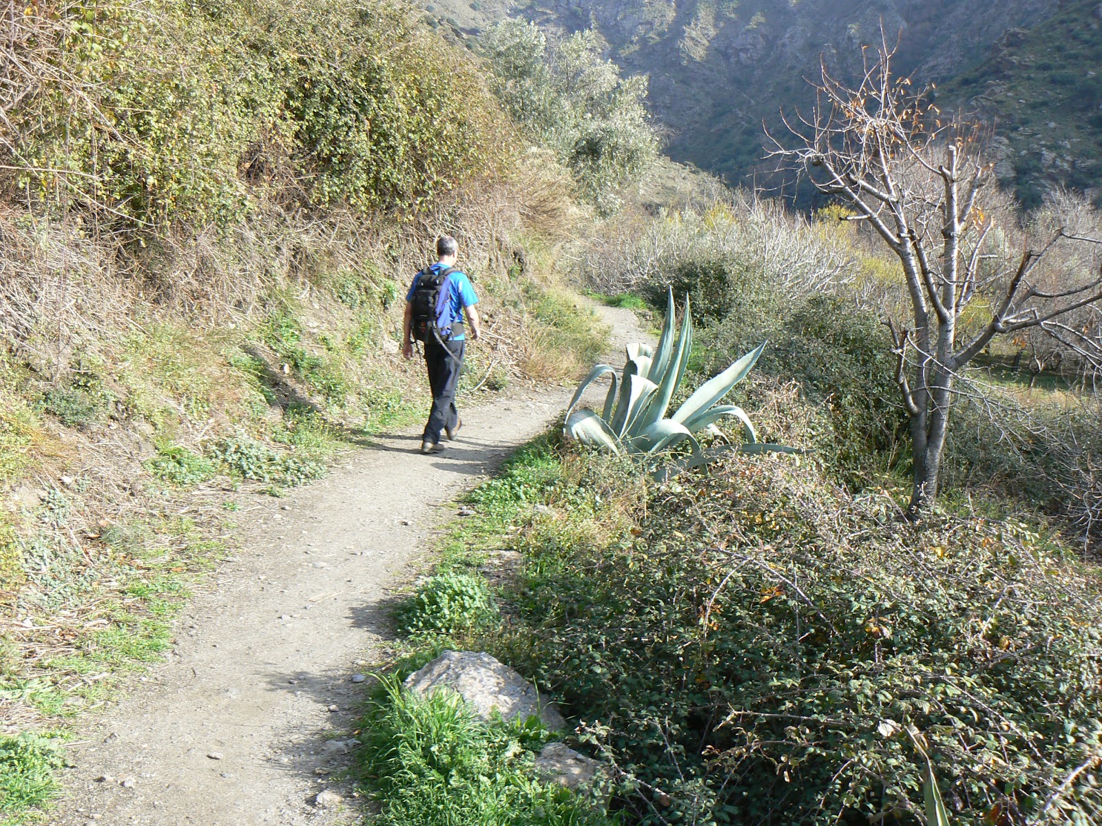
Paths take you through cultivated terraces often with almonds and olives down into rocky valleys with rivers flowing (although some are dry in the summer months). The paths are often lined with wild flowers during the spring and early summer and occasionally with wild tomato hedges and mulberries later in the year.  As you walk along it is not uncommon to pass the local goatherd walking his goats foraging for food and browsing the bushes either side of the path. Sometimes you have to pinch yourself to remember this really is the 21st Centaury!

Iberian Ibex "Cabra de Monte"
Keep an eye out for the wildlife as you walk. Eagles and vultures are common but there may well be decorative hoopoes and bee-eaters as well as a host of other birds.  You will hear scuttling noises revealing that a gecko is getting out of your way or you might just happen upon one! Cabra de Monte (Iberian Ibex) is common in the more remote parts of the valleys.

A unique feature of the area are the acequia’s, water channels that transport water from the steams and distribute it to the hill farms around the hillsides. Although it was the Romans who first introduced them to this area, the present system of acequia’s date back to the time when the Arabs ruled Spain. Most of the acequia’s have narrow paths running beside them which make for great walking and the presence of water attracts many wild flowers.  Some acequia’s are lined with ancient chestnut trees.

Walking beside an Acequia
It is possible to walk in the Alpujarra throughout the year with the exception of the summer months. The Alpujarra gets very hot in summer and too hot for most people to enjoy walking.  In July and August it is possible to walk high up in the Sierra Nevada Mountains where the temperatures are cool, 15 to 25 degrees depending on height and wind strength.  Walking in the winter months in the Alpujarra is usually o.k. and if the sun is out you might even be wearing shorts and tee shirt in February! If staying in one of the higher villages it is not uncommon for 2 or 3 days snow a couple of times each winter.

We are based near Lanjaron which is a good for access to the whole Sierra Nevada Mountain range.  If I was looking for a base in the Alpujarra for a walking holiday I would consider one of the especially pretty villages of Capileira, Bubion or Pampaneira. A lot of walkers stay in Capileira and there is usually some kindred spirit to strike up conversation with in a bar.  There is also the National Park Information office here. 

A car is useful in this area though using public transport is possible as there is reasonable public transport. Details of the bus company and time table in English can be found on the Sierra Nevada Guides website.

Alpujarran Chimneys
The area’s popularity has been increased by Chris Stewarts book, Driving over Lemons which paints an honest picture of what it’s like living in the area. A good read in its own right but you may enjoy your visit more after reading this.

There are some suggestions as to suitable walks on the Sierra Nevada Guides website with free downloads, these confine themselves to the western Alpujarra, Lecrin Valley and western Sierra Nevada. A useful walking book is Holiday Walks in the Alpujarra by Jeremy Rabjohns. Maps can be bought in the U.K. from Stanford’s and we recommend Sierra Nevada, La Alpujarra 1:40 000. Maps are flimsy and you might like to cover them in sticky back plastic before leaving the U.K.

Sierra Nevada Guides are the only company of qualified British Guides based in the area.  We are happy to advise you on route choice or guide you on a more challenging itinerary.
Spring in the Alpujarra

Monday, 15 October 2012

GR240 The Sendero Sulayr


GR 240
The Sendero Sulayr or The “Mountain of the Sun” long distance path.

The Sendero Sulayr is Spain’s longest circular long distance path. This 300 Km long path makes a circuit of the Sierra Nevada Mountain Range and if completing the whole circuit has an ascent of 9800m! Although being a circuit it doesn’t matter where you start, its official start is from the National Park Information Centre at El Dornajo on the road from Granada towards the Sierra Nevada ski resort.  The path is mainly at heights of between 1800m and 2200m though occasionally higher (up to 2460m) and lower.


The Sierra Nevada was Spain’s first national park and is its largest.  The highest mountain in mainland Spain, Mulhacen 3482m is here as is Cerro del Caballo 3005m being Europe’s most westerly 3000m peak. Given the right conditions it is perfectly possible to include these two mountains in your Sulayr itinerary and is worth considering.


The regional Government of Andalucia (The Junta de Andalucia) and the Sierra Nevada National Park authority opened this path in 2007. Officially it has 19 stages, starting and ending at El Dornajo though the stages seem to end in arbitary places in the middle of nowhere! It is possible to combine some of the stages so as to complete the circuit in 15 days, especially if you are supported and not having to carry heavy packs. Because the route only passes through 2 villages, carrying and / or obtaining food is a problem, so for most people, detours will have to be made and the walk unsupported it is likely to take around 21 days making it a huge undertaking. Fortunately Sierra Nevada Guides operate a support service so with travel to and from the U.K. the route is possible in 17 days.


Guidebooks and Maps for The Sendero Sulayr – GR40
Trevenque, day2
Editorial Penibetica have produced a guidebook to the route “Sendero Sulayr” in English, which is available from Stanfords at £29.95.  This guide contains all the maps and information you require for completing the route.  It doesn’t map enough to allow you to ascend either Caballo or Mulhacen.  Caballo can be included as a variation to day 3, though if wishing to include Mulhacen, you will need an additional day.  Think also about including a rest day or two into your itinerary, especially if doing it unsupported.  You can use rest days to get down to villages for supplies of food. (remember most shops in Spain do not open on Sundays and that there are lots of “local” bank holidays).


                        Distance            Height Gain            Time
Stage 1            14.7 Km            850m                      3hrs  50mins

Stage 2            19.4 Km            1042m                    5hrs  30mins

Stage 3            14.5 Km            10m                        4hrs  30mins

Stage 4            8.7 Km              330m                      3 hours

Stage 5            10.5 Km            298m                        4 hours

Stage 6            17.4 Km            916m                        5 hrs  15mins

Stage 7            24.9 Km            974m                        7 hours

Stage 8            16.5 Km            344m                        5hrs  30mins

Stage 9            20.6 Km            325m                        5hrs  45mins

Stage 10            15.2 Km          535m                        5hrs  30mins

Stage 11            20.7 Km          932m                        7hrs  30mins

Stage 12            16.9 Km          188m                        5 hours

Stage 13            11.2 Km          716m                        4 hours

Stage 14            19.2 Km          467m                        5hrs  30mins

Stage 15            10.2 Km          141m                        3hrs  30mins

Stage 16            21.4 Km           566m                        7 hours

Stage 17            16 Km              664m                        5hrs  15mins

Stage 18            14.5 Km            90m                         5 hours

Stage 19            7.1 Km              438m                       2hrs  30mins


When to do The Sendero Sulayr – GR40
Picking Cherries near Trevelez
Because parts of this route are at an altitude where snow lies during the winter, then the only months that are completely free of snow are likely to be May to October. That said, it is perfectly possible to do the route some years in April and November / early December (it all depends on the amount of snow which has fallen over the winter months).  Forget August, it is too hot!

Because you will need to stay at the Postero Alto Refuge, which is open only at weekends or every day from 1st July to 15th September, then July is the obvious choice unless you can plan to arrive at a weekend! Otherwise you'll have to camp outside.

Accommodation on The Sendero Sulayr – GR40
The Sulayr is not a walk with regular accommodation, mountain huts or campsites. To do the walk unsupported you will have to be prepared to wild camp and “rough it” though a tarp would be sufficient in most cases. Even with support, there are at least 2 nights where due to remoteness you would have to stay in Refuges, 1 staffed (at weekends) the other just a stone shelter.  Careful planning is the key to this walk.


Monday, 1 October 2012

Climbing Mulhacen in Autumn and Early Winter


Summer has now departed in the Sierra Nevada and the first snows of autumn have already fallen.  Snow in September and October rarely stays very long, often melting overnight. This short article is intended to give some pointers about how to tackle Mulhacen in normal Autumn conditions i.e. before there is a build up of permanent snow on the west ridge and face.

Mulhacen Summit
The normal way to tackle Mulhacen in a day is by catching the National Park bus from Capileira up past the “barrier” at Hoya del Portillo and up to Mirrador Trevelez 2800m. This bus usually ceases to run in October (check with the information office in Capileira for the latest bus schedule), but it is possible to drive up to the road head at Hoya del Portillo.  If the road up to Hoya is blocked by snow, then don’t contemplate climbing Mulhacen in a day.

Mulhacen in a day from Hoya del Portillo
4 to 5 hours in ascent from 2100m to 3482m.

Before any ascent of Mulhacen you should ascertain the actual conditions on the mountain and look at the weather forecast. The hut guardian of the Poqueira Refuge posts weekly updates as to conditions on the mountain throughout the winter months.

Take note of the wind strength as high winds can make progress slow and even lead to having to retreat.

From Hoya del Portillo, take a path that leads from behind the guards hut, up through the forest to join the firebreak just beneath the viewpoint of Puerto Molino.

At Puerto Molino looking towards Mulhacen
From Puerto Molino to Mirador Trevelez, the nicest way is to take the small path leading up to the ridge passing the minor summit of Prado Llano 2577m, eventually joining the dirt track road prior to reaching Mirrador Trevelez (where the summer bus stops). Alternatively you may follow the dirt track road from Puerto Molino.

Continue along the dirt track road for a further 600m until you reach a junction. Left leads towards the Poqueira Refuge. Here we leave the dirt track road which continues to the Caldera Refuge and take a path on the right which leads up the south ridge of Mulhacen.

As you ascend you are looking at the lower summit of Mulhacen 3361m with a trig point on top.  The actual summit is around 20 minutes beyond.

Descent
If there is snow lying, the safest descent is by returning back down the south ridge.

If there is no snow then the path down the west face to near the Caldera is an option.  This leads back to the dirt track road which can be followed back towards Mirrador Trevelez.

 Never underestimate Mulhacen. Just because it is a “walk” in summer conditions, in deteriorating weather, snow and ice, navigation can be difficult and the going underfoot treacherous.  Always go properly equipped for the conditions. Remember the days are getting shorter and take a torch. If you are uncertain, contact us and discuss the possibility of hiring a qualified International Mountain Leader.

Friday, 28 September 2012

Snow arrives in The Sierra Nevada!


The first autumn storm bringing snow has arrived today in The Sierra Nevada with snow lying at 2600m on the northern slopes. We use the webcams at: the Sierra Nevada Ski resort and the 
Poqueira Refuge to glimpse into the mountains. Today, both of these are showing snow!
Near the summit of Cerro del Caballo 3011m, Europe's most westerly 3000m peak.
Although the snow from these early storms does not normally stay very long it’s time to start thinking about winter conditions and being prepared, carrying clothing and equipment to be safe in winter conditions.  Remember too that the days are drawing in and it’s getting dark earlier.

Autumn storms are not all bad!  The rain and snow bring much needed water to replenish the springs that many hill farmers depend on. Our own "mountain cortio" situated at 1300m relies on two natural springs for its water supply, one of which has dried up during the summer.

Looking towards Mulhacen from Puerto Molina
Winter in the Sierra Nevada brings a whole new dimension  to the walking and mountaineering. It’s all well and good having the right equipment, but good navigation skills are essential as is a knowledge of the weather and how to look after yourself. The British Mountain Council have a booklet that can be downloaded free of charge that contains some useful information for hill walkers.  They also have a good video called “winter skills” that’s worth viewing and is good revision too, even for seasoned winter mountaineers.

Of course it’s worth considering skills from qualified professionals.


Sun and blue skies, snowshoeing in the upper Rio Lanjaron
If you want to brush up on your navigation and mountain skills, a day with us in the mountains starts from 30 Euro’s to 70 Euro's depending on numbers.

Thursday, 30 August 2012

Sandra’s Last Munro


Sandra’s Last Munro
Sandra is a regular visitor to The Sierra Nevada and last year managed The Integral, (a traverse of all the 3000m peaks in the Sierra Nevada), accompanied by Sierra Nevada Guides.

Sierra Nevada Guides were invited to accompany Sandra on her final Munro, Driesh 947m near Glen Doll in Scotland.

Around 30 of us accompanied Sandra to the summit in deteriorating weather where celebration drinks, cava and a range of single malt whiskies, were consumed before descending and retreating to the pub for “stovies” and more drink.

Congratulations Sandra on completing your Munro’s!

A Munro is a Scottish mountain with a height of 914m or higher. There are 283 Munro’s listed in the SMC guide though there is the odd dispute over a couple of peaks.

After experiencing the Scottish summer weather and the infamous midge, we now remain convinced that Spain's Sierra Nevada is the place to be!

It should be noted that Mike and Jane of Sierra Nevada Guides have a house at 1300m above sea levelhigher than most Munro's.

Monday, 6 August 2012

Rock Climbing in and around The Sierra Nevada (Granada)

Rock Climbing in and around The Sierra Nevada (Granada)


Although some of the “bigger” climbing venues are documented in David Munilla’s rock climbing guide to Andalucia some are only partly described whilst some of the smaller venues not described at all. The Sierra Nevada contains mainland Spain’s highest mountain (Mulhacen 3482m) and the area around it some fine rock climbing too.  

Venues include:
Alfacar, Capileira, Lagos, Diezma, Lanjaron, Monachil, Motril, Motril (los Vados), Niguelas, Orgiva and Pinos del Valle.


Further information including some free downloads are available from the Sierra Nevada Guides website


Climbing at Niguelas


Sierra Nevada Guides are qualified to introduce you to rock climbing providing “taster” sessions and tuition on the various cliffs in the Sierra Nevada and surrounding area. The area has something for everyone from gentle easy angled climbs for the novice to steep and overhanging climbs for the expert.

If you are planning a climbing trip to the area we will be happy to answer any questions you may have and help or advise on hiring accommodation.


Sierra Nevada Guides are a company of International Mountain Leaders and climbing instructors based in Spain's Sierra Nevada.

Friday, 3 August 2012

Autumn in the Sierra Nevada and Alpujarra


Autumn in the Sierra Nevada and Alpujarra
The autumn is a great time to visit as the heat from summer starts to fade and walking and climbing at lower altitudes becomes possible again. Although there will be occasional rainy days, any moisture brings life back to the plants and a second growing season begins.

Walking in The Taha - December
Any rain in the valleys is likely to bring a dusting of snow on the high peaks, though this will melt quickly as snow tends not to lie before November.  Water will be flowing again in the acequias  (water channels) which are often lined with chestnut trees who’s leaves turn to gold then brown as autumn progresses.

This is a great time to visit for a walking holiday.  Low season hotel prices coupled with mainly settled weather that will seem like summer to anyone from Britain.  Walking in the Alpujarra (hill walking) and Sierra Nevada (mountain walking) is as good as it gets with some truly memorable days to be had.

Some of our favourite walks  include:
A circuit in the Taha from Busquistar:
A circuit to the Poqueira Refuge for lunch;  and
An ascent of the Cerro del Caballo which at 3011m is Europe’s most westerly 3000m peak.

Trevenque in October
An ascent of Mulhacen (mainland Spain's highest mountain 3482m) is a must for serious walkers and mountaineers and we have a range of itineraries listed on our website, whether you need a guide or not.

To make the most of your visit, check out our website where you’ll find all sorts of useful information and suggested itineraries.  If you have a question about the area that isn’t answered on our website do get in touch, we are always happy to advise.

Like all mountains, these can be serious too.  Only venture into the hills if you have the right skills.  You can always hire a guide from Sierra Nevada Guides.


Sierra Nevada Guides are a company of qualified International Mountain Leaders.